Search departures
Dayton-Wright Brothers Airport
The Dayton-Wright Brothers Airport (MGY) is a general aviation airport comprised of 527 acres and is located approximately 12 miles south of the City of Dayton in Miami Township, Ohio. It is positioned east of I-75 at the Austin Blvd. exit 41. The Airport is owned and operated by the City of Dayton and serves as the reliever airport for Dayton International Airport.
Dayton-Wright Brothers Airport operates 24 hours per day, 7 days a week and primarily serves corporate and personal aircraft users. The Airport has many T-hangars available for lease, tie-down space and land available for personal or corporate hangar development. For those requiring aircraft maintenance and other services, the Airport has two on-site fixed based operators.
The Airport is also home to Wright “B” Flyer, Inc., a non-profit organization that maintains a hangar museum honoring the accomplishments of the Wright Brothers and operates growing fleet of “lookalike” reproductions, including a historically accurate and beautifully crafted replica of the Wright Brothers’ Model B airplane, which visitors can arrange to fly in!
For additional information about the Airport, please contact:
Gilbert Turner, Director of Aviation
937.454.8212
gturner@flydayton.com
Location
10600 N Springboro Pike, Miamisburg, OH 45342
DWBA History
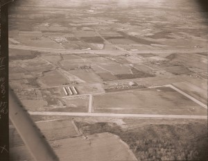
Originally named the “Montgomery County Airport,” the Dayton-Wright Brothers Airport was constructed in the early 1950s by the industrialist, Charles F. Kettering, to support one of the nation’s first corporate flight departments. The Airport’s primary role was to serve as a private general aviation airport for southern Montgomery County, Ohio.
The City of Dayton leased Montgomery County Airport from the Kettering Foundation in 1970 with the objective of utilizing it as a general aviation reliever airport to off-load the ever increasing amount of general aviation traffic from the Dayton International Airport. At that time, the Airport facilities consisted of two runways, three 12-unit T-hangars, one large conventional hangar and an administration building. The City of Dayton leased the Airport from the Kettering Foundation until 1974, when the Airport was purchased by the City with the assistance of federal grants for $1,490,000. After the City’s acquisition of the Airport, it was renamed “Dayton General Airport South.” In 1977, the administration building was replaced by a new facility at a cost of $1,060,000.
In February 1990, an Erie, Pennsylvania business established Northcoast Executive Airlines. The airline initiated daily scheduled air carrier service from Dayton General Airport South to Detroit and Flint, Michigan; Chicago, Illinois; and Cleveland, Ohio. Due to a national and regional economic recession, which affected business-related air travel from Dayton to the industrial region of the Great lakes, Northcoast Airlines ceased operations in January 1991.
To honor the Wilbur and Orville Wright while celebrating Dayton’s rich aviation history, Dayton General Airport South was renamed “Dayton-Wright Brothers Airport” on December 6, 1995. Today, airport facilities include a 4,500-foot runway equipped with a partial precision approach consisting of a localizer (LOC), approach lighting system (MALS), runway lighting (MIRL) and a visual approach lighting system (VASI).
Find more information at realestate.flydayton.com.
Businesses and Tenants
Fixed Based Operator (FBO)
First Flight Aviation
(937) 885-3662
www.firstflightaviation.com
Higher Ground Helicopters Inc.
(513) 217-6700
www.hghelicopters.com
Other Businesses and Tenants
Aero Jet Wash
(866) 381-7955
www.aerojetwash.com
Dayton Pilots’ Club
www.daytonpilotsclub.org
Wright “B” Flyer, Inc.
www.wright-b-flyer.org
National Aviation Heritage Area
(937) 443-0165
www.visitnaha.com
Airport Facts
Identifier: Lat/Long: Elevation: Distance from City Center: Time Zone: | MGY N39°35.34′ W84°13.49′ 957′ MSL 10 nautical miles south UTC-5 (-4 during Daylight Saving Time) |
Use: Control Tower: Traffic Pattern Altitude: | Open to the public No 0800-2000 1957′ MSL |
Communications: Weather Data Sources: | CTAF/UNICOM 122.8 ASOS 118.375 or (937) 885-2171. HIWAS 114.5 DQN. |
Fuel: Parking: Oxygen: Airframe service: Powerplant service: | 100LL, JET A Hangars and tie-downs High pressure Major Major |
Runway 2-20 Dimensions: Surface: Threshold displacement: | 5000′ x 100′ Asphalt/Grooved Runway 20 threshold displaced 590′ |
Interested in Land Development?

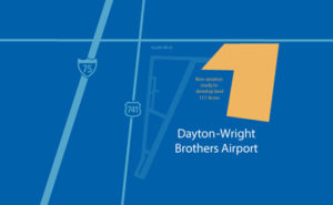
We have 117 acres of non-aviation land ready to develop located at the Dayton-Wright Brothers Airport (MGY) in Miamisburg, Ohio. Contact us for all your development needs.
Gilbert Turner, Director of Aviation
937.454.8212
gturner@flydayton.com


